
There’s a full list of believed impact craters in this article and a list of unconfirmed impact craters here (this is the map) I include here some of them, but also craters of different origins.
The causes of the craters’ formation mentioned here are the ones quoted by the original sources. I compile them here because of the possibility that some of these craters might be of an electrical origin.
Brukkaros Mountain, Namibia
Wikipedia says:
The mountain is a large extinct volcano, in the form of a ring mountain (a so-called tuff ring) with a diameter of about 4 km[2] and has been formed by an explosion when rising magma met groundwater and superheated it.
If so, that would be similar to the 1991 eruption which created the current Mount Pinatubo caldera (2.5 km wide).
Fort Rock-Christmas Lake Valley Basin, Oregon
The Fort Rock basin maar field includes over 30 hydrovolcanic landforms.
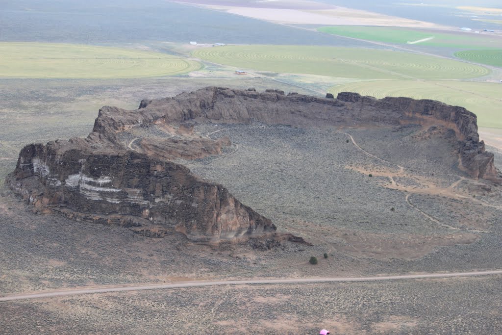
Fort Rock, Oregon. PD by jmoorefield2 via Panoramio.
Crater Lake, Oregon
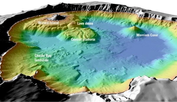
Details of features beneath the surface of Crater Lake constructed using data from the 2000 bathymetry survey. Colors range from orange to blue with increasing water depth. Credit USGS via U.S. Geological Survey Fact Sheet 092-02
Maar lakes in Sweard Peninsula, Alaska
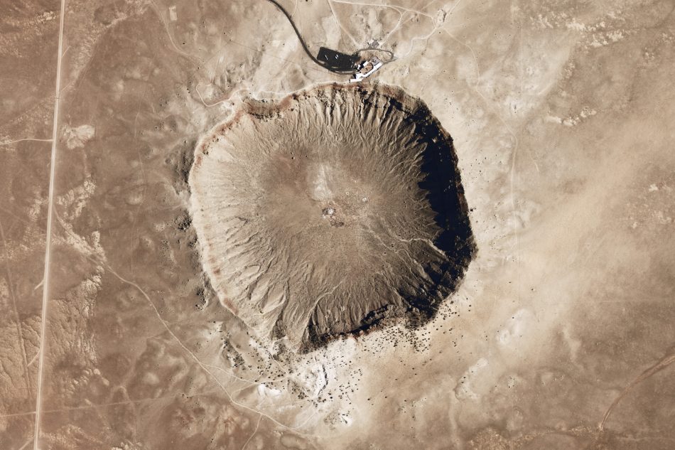
Meteor Crater, Arizona
Meteor Crater, Arizona. PD by Volkan Yuksel via Google Maps.
Thunderbolts.info has an article on this one.
Campo del Cielo, Argentina
Wikipedia says:
A crater field of at least 26 craters was found in the area, with the largest being 115×91 meters. The field covered an area of 3×18.5 kilometers with an associated strewn area of smaller meteorites extending farther by about 60 kilometres (37 mi). At least two of the craters contained thousands of small iron pieces. Such an unusual distribution suggests that a large body entered the Earth’s atmosphere and broke into pieces which fell to the ground. The size of the main body is estimated as larger than 4 meters in diameter. The fragments contain an unusually high density of inclusions for an iron meteorite, which might have facilitated the disintegration of the original meteorite. Samples of charred wood were taken from beneath the meteorite fragments and analyzed for carbon-14 composition. The results indicate the date of the fall to be around 4,200–4,700 years ago, or 2,200–2,700 years BC.[2][5]
Lake Bosumtwi, Ashanti, Ghana
Vredefort crater, South Africa
Wikipedia says:
The Vredefort crater is the largest verified impact crater on Earth, more than 300 km across when it was formed.
(…) The asteroid that hit Vredefort is estimated to have been one of the largest ever to strike Earth (at least since the Hadean Eon some four billion years ago), thought to have been approximately 15–20 km (9.3–12.4 mi) in diameter.[3]
Aorounga crater, Chad
The exposed remnant of the crater is 12.6 km in diameter. Thunderbolts article.
Kebira Crater, Lybia
Thunderbolts says:
One intriguing aspect of the discovery is its close association with a mysterious field of yellow-green glass, broken into large chunks, littering the dunes in the Great Sand Sea of southwestern Egypt.
Wilkes Land Crater, Antarctica
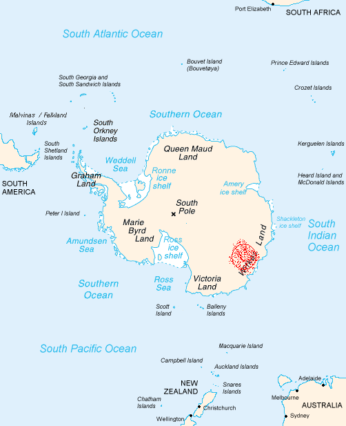
Map of Antarctica showing Wilkes Land, with the crater conjectured by von Frese and team marked in red. CC BY-SA by enwiki via Wikimedia Commons.
Thunderbolts has an article on this one.
The Eye of the Sahara, Tenoumer Crater, Temimichar Crater
There’s 3 Thunderbolts articles here, here and here on this crater.
In the October 28, 2002 Astronomy Picture of the Day the “explanation” goes like this: “What on Earth is that? The Richat Structure in the Sahara Desert of Mauritania is easily visible from space because it is nearly 50 kilometers across. Once thought to be an impact crater, the Richat Structure’s flat middle and lack of shock-altered rock indicates otherwise. The possibility that the Richat Structure was formed by a volcanic eruption also seems improbable because of the lack of a dome of igneous or volcanic rock. Rather, the layered sedimentary rock of the Richat structure is now thought by many to have been caused by uplifted rock sculpted by erosion… Why the Richat Structure is nearly circular remains a mystery.”
And also:
It is interesting to note that the Richat Crater is very slightly oval and its major axis is inline with the two other craters. We suggest that these three craters are part of the same discharge event series, conventional “dating” notwithstanding.
And other articles referring to a similar layered crater in Mars’ northwestern Schiaparelli Basin here and here.
The individual maps are here:
Gooches “crater”, Australia


Thunderbolts article.
The Yolngu tribes have chronicled lightning as an energy burst arising from the land. Gods as tall as mountains who strode across the sky were also said to have created Australia and taught the story of creation to its inhabitants.
Manicouagan Crater, Canada
Thunderbolts article.
Popigai Crater, Siberia
Wikipedia says:
The Popigai crater (or astrobleme) in Siberia, Russia is tied with the Manicouagan Crater as the fourth largest verified impact crater on Earth.[2][3]
Thunderbolts article.
The Kondyor Massif, Siberia
Thunderbolts article.
Chicxulub Crater, Gulf of Mexico
Gravity anomaly map of the Chicxulub impact structure. The coastline is shown as a white line. A striking series of concentric features reveals the location of the crater. White dots represent water-filled sinkholes (solution-collapse features common in the limestone rocks of the region) called cenotes after the Maya word dzonot. A dramatic ring of cenotes is associated with the largest peripheral gravity-gradient feature. The origin of the cenote ring remains uncertain, although the link to the underlying buried crater seems clear. PD by Geological Survey of Canada via USGS.


